Day Hikes from city of Tokyo using public transportation: Walking in Woods 6
Mt. Ogiri and Sadamine Pass in Saitama
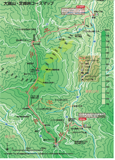
MAP Mt. Ogiri and Samine Pass PDF
![]()
Click the Button Above for “Like It “にほんブログ村
Great HIDE IN on weekend. This is day hike from central Tokyo. This time the walk starts and finishes at a bus stop – not a train station which makes me feel easy. We have to be careful about the bus schedule due to the limited service. Make sure you can go home after the hike. You can take a bus from Ogawa Machi Station on Tobu Tojo Line. It takes about 1 – 1.5 hour from Shibuya, Ikebukuro or Shinjuku plus about 20 minutes bus ride.
Route Distance: 8 km
About 5 hours walk
Highest point : 766 m
Lowest point : 200 m
Difference in elevation: 560 m


shiroishishakotimetable5036 PDF
Please check the latest time table with the HP of Eagle Bus clicking here
http://www.new-wing.co.jp/rosen/higashichichibu/#rosenzu1001
[googlemaps https://www.google.com/maps/embed?pb=!1m18!1m12!1m3!1d51620.705108751295!2d139.18245197739768!3d36.03752840868619!2m3!1f0!2f0!3f0!3m2!1i1024!2i768!4f13.1!3m3!1m2!1s0x601ecdc609ec47a5%3A0xf6c58970a138a698!2z44OQ44K55YGcIOeZveefs-i7iuW6qyjjgqTjg7zjgrDjg6vjg5DjgrnmoKrlvI_kvJrnpL4p!5e0!3m2!1sja!2sjp!4v1504332053580&w=600&h=450]


Reblogged this on vanillafrosted.